

← Back to Property List
Curtis Homestead Conservation Area
Location and Description:
Location: Leeds, Maine
Property Description: The 360-acre Curtis Homestead is the childhood home of former Maine Governor Kenneth M. Curtis. This property provides an excellent example of forest succession patterns that occur in New England as agricultural activity diminishes over time. The property includes fields, mature woodlands and wetlands, beautiful trails, and excellent birding.
Directions: From Route 202 in Monmouth, go west on the Bog Rd. for about 1.5 mi.
Usage and Directions
Allowable Uses: hiking, nature observation, cross-country skiing, snowshoeing, hunting in season. No motorized vehicles. Dogs are allowed on a leash or under voice command. Please clean up after your pets.
Lower Fields Loop Trail: 1 mile, easy; starts at the kiosk and winds through woods.
Upper Fields Loop Trail: 0.5 mile, easy; starts at the kiosk and follows the first section of the Curtis Rock Trail. At the first stone wall the trail loops back around to the field.
Curtis Rock Trail: 1.4 mile, easy/moderate; with a bog overlook at “Curtis Rock.”
Woodlot Trail: 0.7 miles, moderate trail passes through a mixed hardwood forest. This loop trail begins at Curtis Rock (a glacial erratic) and follows the western edge of the bog, providing several wonderful views.
Caution: Ticks are a problem in the fields in the summer. Also, parts of the Curtis Rock Trail and the Woodlot Trail have been closed in the past during bird nesting season, April through July.
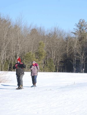
KLT's Annual Family Winter Fun Day, at Curtis Homestead.
Photo: Kelsey Gibbs
Parking: Parking lot is located on the right, look for KLT sign.
History:
The stone walls and abandoned farm lands at The Curtis Homestead Conservation Area are evidence of the patterns of land use that defined Maine’s 19th century agricultural era. Abner Curtis Sr., formerly from Massachusetts, settled in this region in the District of Maine in 1800, during a time when proprietors for the Pejepscot Patent were selling large settlement lots. Abner and a brother settled next to each other in the area that was soon to be known as Curtis Corner. The Curtis family might have selected this land because it already had a source of food for their oxen and cattle: The bog that borders the Curtis woodlands to the east could have been a source of meadow or swale hay before “English hay” was planted.
Featured in Between Person and Place